Geomni UK Newsletter
October 2020


After a busy September preparing new editions of our datasets we have been back in the swing of events, webinars and meetings although almost entirely digitally. We were pleased to be part of the AGI Cymru event earlier in the month and are looking forward to participating and sponsoring AGI GeoCom in November.

We had started a limited return to our office before the recent restrictions came in and it was good to get together as a team face to face. You can read more about the team and our participation in Verisk Volunteer week below.

This newsletter focuses on two of the announcements we made last month, notably the new UKBuildings API, and UKMap integration with Open Identifiers. Both of these will also be covered in forthcoming webinars. Thank-you if you have attended one of our recent webinar series. You can see recordings of past ones and learn more below.

Keep safe,

Tom
UKBuildings data made accessible via an API

In addition to launching the enhanced UKBuildings edition last month with GB coverage of building height, use and residential type we also announced that the data is accessible via an API (Application Programming Interface). The UKBuildings API allows developers to integrate detailed property level data into applications and services.

As shown in the example above, the API accepts an address or UPRN as input, and returns the UKBuildings attribution for the specified property. This includes building height and number of floors, use and structural information. UKBuildings data can significantly enhance the information available about a property to speed and improve decision making.

Please contact us for more details.
UKMap Integration

Edition 25 of UKMap published in September included the new Ordnance Survey Open Identifiers, specifically the UPRN (Unique Property Reference Number address identifiers) and USRN (Unique Street Reference Number). These simplify the integration of detailed UKMap attribution with other datasets.

For example, UKMap includes detailed information about street characteristics, crossings, parking bays and cycle lanes. These are now linked to USRNs which means firstly that all information relating to a specific street is now linked, and secondly that this information can easily be shared with other applications.
Two new webinars added to the series

So far, in the latest series of webinars led by the team of experts here at Geomni UK, we have explored the detailed information available in the latest edition of the UKBuildings and UKMap databases.
  • UKBuildings - a new and improved national database of building characteristics (view recording)
  • UKMap - an expanded and improved database of London (view recording)
  • A deep dive into Geomni UK's national database of building characteristics (view recording)
We have now expanded the series by adding two new webinars focusing on Geomni UK’s national land-use dataset and our web services and APIs:
Verisk Volunteer Week

Every year, Verisk employees around the globe spend a week giving back to community.

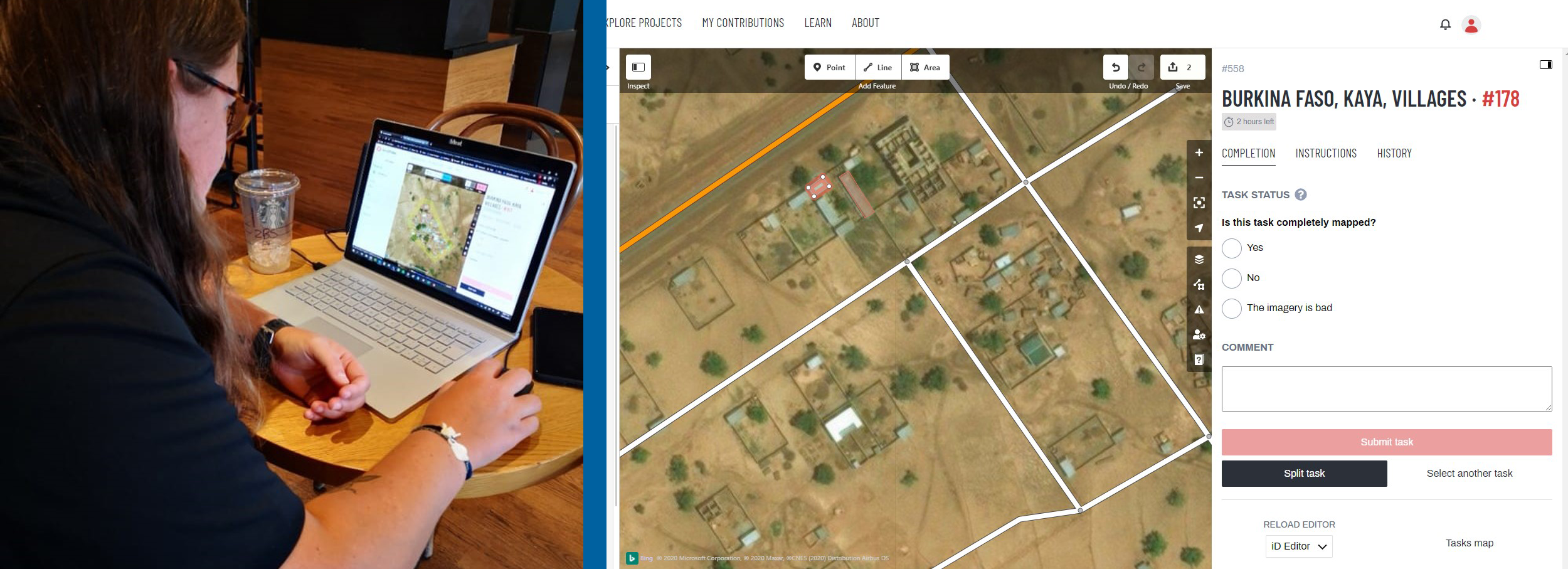
As part of Verisk Volunteer Week, the Geomni UK team participated in a Missing Maps Mapathon, an initiative where participants from around the world remotely 'map' un-mapped areas to help humanitarian organisations provide aid to some of the planet's most vulnerable people. Geomni UK support missing maps events held regularly in Cambridge but this was a chance for the whole team to get involved.

Each year, disasters around the world kill nearly 100,000 and affect or displace 200 million people. Now we are all affected by a global pandemic. Many places are literally 'missing' from any map so anyone responding to disasters or a pandemic lacks information to make decisions regarding relief efforts.

We managed to map around 1500 buildings in an area of Burkina Faso, so thank you to the team for getting involved!